
Page 381 - Control de la Contaminación - Lago San Jacinto (Afluentes)
P. 381
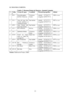
B)  SEGUNDA CAMPAÑA

                                Cuadro  2: Resumen Puntos de Muestreo - Segunda Campaña
                  N    Códig    Cuerpo de agua       Localidad       Ubicación geográfica      Altitud
                  º    o
                  1    AF-1     Desembocadura        Tolomosa        Latitud:    21º36’43” S   1896 m.s.n.m
                                del Río Tolomosa     Centro          Longitud: 64º45’19” O


                  2    AV-1     Área  del  lago  San  San Jacinto    Latitud:    21º35’53” S   1897 m.s.n.m
                                Jacinto  próxima  a                  Longitud: 64º44’47” O
                                Tolomosa Centro
                  3    AF-2     Área  Central  del  San Jacinto      Latitud:    21º35’55” S   1895 m.s.n.m
                                Lago San Jacinto                     Longitud: 64º43’51” O
                  4    AV-2     Río el Molino        Molino          Latitud:    21º35’36.1” S   1894 m.s.n.m
                                                                     Longitud: 64º36’05.4” O
                  5    AV-7     Quebrada Salada      Tolomosa        Latitud:    21º35’28.7” S   1892 m.s.n.m
                                                     Norte           Longitud: 64º46’05.0” O
                  6    AV-8     Canal  de  riego  Santa Ana          Latitud:    21º38’15.3” S   1818 m.s.n.m
                                cruce  al  Valle  de                 Longitud: 64º38’18.0” O
                                concepción
                  7    AV-9     Río Tolomosita       San Andrés      Latitud:    21º36’39.3” S   1977 m.s.n.m
                                                                     Longitud: 64º49’07.7” O
                  8    AV-10  Río        Tolomosa  Tolomosa          Latitud:    21º37’24.6” S   1924 m.s.n.m
                                Grande               Centro          Longitud: 64º46’11.6” O
                  9    AV-11  Río Mena               Bella Vista     Latitud:    21º38’32.5” S   1926 m.s.n.m
                                                                     Longitud: 64º46’47.7” O
                  10  AV-12  Río Sola                Sola            Latitud:    21º38’28.5” S   2030 m.s.n.m
                                                                     Longitud: 64º49’59.1” O
                  Fuente: Elaboración Propia, (2008)


                                                              198