
Page 9 - COSECHA DE AGUA EN EL CANTÓN TOMAYAPO
P. 9
Empresa de Servicios Generales
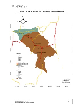
Mapa Nº 4: Vías de Conexión del Proyecto con el Centro Capitalino
27 0 0 0 0 27 5 0 0 0 28 0 0 0 0 28 5 0 0 0 29 0 0 0 0 29 5 0 0 0 30 0 0 0 0
N #
W E #
#
#
7655000 S # # 7655000
#
#
# Chinchilla
#
Pucu P am pa #
#
7650000 Huancar 7650000
#
#
M onte G rande
#
San F rans isco #
#
Loros
#
7645000 # La Parroquia 7645000
#
Obispo del C arm en
Cantones.shp #
Carrizal #
Chayasa
Curqui #
El Puente
Huarmachi
Ircalaya
Iscayachi #
Paichu
7640000 Cami_ muni_ futuro.shp 7640000
Tomayapo
Red departamental
Red municipal de primer orden Cieneguillas #
#
Red municipal de segundo orden
Subcuencas.shp #
Afl. dir. Camblaya
Afl. dir. San Juan del Oro
Paicho #
Tomayapu
# Comunidades.shp
Cantones.shp
Carrizal
7635000 Curqui 7635000
Chayasa
El Puente
Huarmachi
Ircalaya #
Iscayachi #
Paichu #
Tomayapo
#
Fuente: PMO T-Z ONISIG -PDM
# # Diseño: EL CEIBAL S.R.L.
# Proyeccion UTM
Datum Area: Bolivia
# Elipsoide Internacional 1924
# Zona 20
#
27 0 0 0 0 27 5 0 0 0 28 0 0 0 0 28 5 0 0 0 29 0 0 0 0 29 5 0 0 0 30 0 0 0 0
Oficina Técnica Nacional de los Ríos
Pilcomayo y Bermejo (OTN-PB) 8
“Cosecha de Agua en el Cantón Tomayapo”